Hungary lies between 45°45' and 48°35' north latitude, roughly halfway between the Equator and the North Pole, in the temperate zone according to the solar climate classification. The climate of Hungary is very variable as it is equally affected by the high-moisture oceanic air masses with more balanced temperature, the fundamentally dry continental air masses with extreme temperature fluctuations, and the mild, high humidity air masses coming from the Mediterranean Sea. In summer, most of the air masses (60-70%) are of marine origin, whereas during the cold winter months, continental air masses are more dominant. The northwest-southeast orientation of the distribution of meteorological elements reflects the influence of the Atlantic Ocean to the northwest and the Mediterranean Sea to the southeast.
Although the extent of Hungary is relatively small and has no significant differences in topography, the effects of the Carpathian Mountains and the surrounding mountains can also be observed in the spatial distribution of climatic elements.
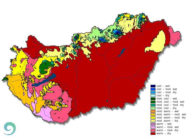
Figure 1
Climatic regions in Hungary (based on climate classification of György Péczely )
The country is located in the zone of western winds, and due to its location - surrounded by the Carpathian and Alpine mountain ranges - the prevailing wind direction is northwest, while southerly winds have a secondary maximum.
Hungary's climate can be classified according to two prominent global climate classification systems. Based on the Köppen classification, a substantial part of the country falls under the Cfa warm-temperate climate zone characterized by a uniform distribution of precipitation and a hot summer climate type. Conversely, according to the Trewartha classification, Hungary is classified under the continental climate type, characterized by long warm seasons. These climate classification systems are inadequate in demonstrating the climatic variations among different regions in Hungary. To address this, György Péczely developed a method specifically applicable to Hungary that categorizes the heat and water supply of regions based on the average temperature during the vegetation period and the aridity index. The resulted climatic zones arise from the combined application of the two criteria. According to the Péczely classification, most of Hungary falls into the warm-dry category. The warm-dry regions are generally surrounded by warm and moderately warm zones (Figure 1), while moderately cool and cool regions can be found only in high-altitude areas. The Bükk Plateau is the only area with cool-wet climatic conditions.


